What must be emphasized from the start is that following traffic patterns is critical for maintaining the safety of all users. Collisions of any sort can be physically devastating to athletes and costs thousands of dollars in medical bills and equipment losses. If we were to offer any single bit of advice it would be to consider there is a “double yellow line” going down the middle of the river that must not be crossed except when properly crossing in to reverse direction on the river. Stay away from the “middle” of the travel lanes at all times. It is far better to come to a stop until an obstruction ahead of you clears than it is to swerve around and cross into oncoming traffic!
These are directions for rowers/crews. (Map at end of section) Paddlers and kayakers should contact the Washington Canoe Club Aquatics Committee for guidelines. Users of rental boats should consult the rental agency for information. Notation of river traffic starts at Fletcher’s Cove and works progressively downstream. Most information concerns rowing shells. Paddlers are asked to use the river closest to the D.C. shore from Key Bridge to Fletcher’s Cove and to use the prescribed traffic pattern downstream.
For simplicity US= upstream, and DS= downstream.
Fletcher’s Cove
Traffic Pattern
- US crews should turn no more than 10-20 strokes above the end of the island on the starboard side (or the DC Harbor Police Buoy if it has been put in place) that signals the beginning of the cove.
- Crews should be aware that there are many rock hazards on the DC side of the cove.
- Paddlers: Boaters that are primarily stationary should try to avoid congesting the area that is a straight line from the bottom to the top of the cove area – this is a thoroughfare for paddlers and rowers traversing through the cove to get either from downriver to Chain Bridge or the reverse. Paddlers should follow “rules of the road” traffic patterns when traversing through Fletcher’s Cove and should try to stay in the traversing lane (and should try to stay away from the inside/protected section of the cove where fishing boats and others may be stationary or slow moving).
Hazards
- Warning– DC MPD Harbor Patrol can enforce the PFD requirement for the Fletcher’s Cove area. You can be ticketed.
- U.S. Rule 33 CFR 175.17(b) (USCG) notes that rowing shells do not fall under the requirement for PFDs, but DC Harbor Patrol has the jurisdiction to make such requirements and enforce them.
- MPD Harbor Regulation 1026 states: All persons aboard any vessel in the area from the southernmost point of the cove commonly known as Fletcher’s Cove in the Georgetown Channel of the Potomac River upstream to the District of Columbia boundary line at Little Falls shall wear a Coast Guard-approved personal floatation device at all times.
- The DC side of Fletcher’s Cove is very rocky, though it appears otherwise.
- Going US there are several rocks about 200 meters before the island that forms the entrance to Fletcher’s Cove.
- Many fishing and recreational craft are either stationary or very slow-moving in this area. It is imperative that moving craft stay aware of this and exercise caution when operating around other craft. Please use good communication and judgment to avoid collisions and close calls.
- Above Fletcher’s Cove to Chain Bridge exist a number of large rocks that are barely visible and just underneath the waterline. Depending on the time of the year, these rocks can be in the traffic lane. Please exercise caution in and above Fletcher’s Cove on both sides of the river.
- The river flow is MUCH stronger in and above Fletcher’s Cove in comparison to near Key Bridge. Additionally, many eddies and whirlpools exist in this section of the river. River users are encouraged to use sound judgment when using this section of the river and understand their skill and boat limitations. This section also becomes drastically more dangerous during and after rainfall and high river flow/level periods
Hens and Chickens
Traffic Pattern
- DS Crews must closely follow the VA shoreline at all times. The area is prone to congestion and is narrow.
- US Crews should follow a nearly straight line from Three Sisters Islands to the Hens and Chickens. In the area between the Three Sisters Islands, and the Hens and Chickens, slow-moving crews or crews wishing to do drills should slide to the DC side of the river to avoid faster-moving traffic going US.
- However, crews must be aware that the river area 250 meters from the DC shore is used by and domain of canoes and kayaks.
- All crew must be aware of the “centerline” of the river in this area and stay to the starboard side of the line! Due to the narrowness of the area, obstacles, and natural profile of the river, the risk of head-on collisions is high!
- Paddlers: should use the “rules of the road” as they traverse through the Hens and Chickens area, staying on the DC side of the main travel lane going up river, and when going down the river on the VA side. Paddlers should try to not stop in the travel lane at Hens and Chickens. If you need to stop or gather, please stay on the DC shore downriver or upriver of Hens and Chickens and out of the travel lane.
Hazards
- There are many submerged rocks around Hens & Chickens that are visible only at different tides. No crews should ever go to the DC side of these islands!
- This area is problematic and can be very congested. The curvature of the river, the change in width of the river on either side of the rocks, the angles of approach both from up and downstream, as well as the narrowness of the space when passing these rocks contribute to the hazards of the area. Specific care should be taken including
- DS crews should hug the DC shore. The shoreline drops off quickly so depth is not an issue.
- Heading US there is a rock on the DC ( 20 meters) shore approximately 400 meters downstream from Hens & Chickens. It is sometimes marked with a white buoy. It is known as “Turtle Rock” or “Mile Rock” and is very capable of destroying the bottom of a boat. Depending on the tide/level of the river, this rock is partially visible. A large portion of the rock is not visible and extends both to the VA and DC sides of the visible portion. River users should pass this rock with ample room on each side.
- Paddlers should not gather/stop in the travel lane at Hens and Chickens. Instead, gather upstream or downstream of the bottleneck/rocks and on the DC side of the river.
- Paddlers should use extreme caution when paddling through the Hens and Chickens rocks on the DC shore side of the rocks. There are a large number of rocks that can hit boats, rudders, skegs, and paddles. It is not recommended to use this travel lane.
Three Sisters Islands to Key Bridge
Traffic Pattern
- When passing between the Three Sisters Islands and the VA shore team boats (4’s and 8’s) should be no more than 3 abreast, smaller boats no more than 4 abreast.
- DS Crews should follow the curve of the VA shore and pick a course through the second arch from starboard of Key Bridge only after passing the Three Sisters Islands.
- DS Exiting Key Bridge, crews should aim for the point of land on Roosevelt Island that is directly opposite Thompson Boat Center at the bend of the river.
- US crews should go through the 2nd arch from DC on Key Bridge and aim for the Three Sisters Island that sits farthest towards the VA shore. The 1st arch of Key Bridge on the D.C. side is reserved for Potomac Boat Club crews who are landing.
- US After passing through Key Bridge, crews should pick a point just to the port side of the Three Sisters Islands. Crews should work together so that they may pass the islands as closely as possible and still remain out of the path of crews headed downstream.
- Three Sisters Islands to Key Bridge are very popular amongst all craft. At times, there are also many leisure boats moored in large groups (called “rafting”), which cause congestion and lack of vision up and down the river.
- Potomac Boat Club (PBC) crews and scullers: when launching from the PBC dock, athletes and coaches should proceed slightly upstream from the dock, towards the Washington Canoe Club (WCC), before turning to head across the river to head DS. Boats should be far enough from the WCC dock to not interfere with paddler launching and landing. Athletes and coaches should give special attention to crews headed US so as not to interfere with them and potentially compromise safety.
- Paddlers: From Key Bridge/Washington Canoe Club, paddlers should stay on the DC shore side of the river to avoid too much congestion on the VA side of the river where rowers use the river. This includes staying on the DC shoreside of Three Sisters and Mile Rock. If paddlers need to use the VA side of the river, follow the rowing traffic pattern referenced in this document (“rules of the road”, but specific to the travel lane on the VA side of the river). Paddlers should keep eyes, ears, and heads up for other boat traffic, including rowers, other paddlers, and motorboats. These boats can come up on paddlers (and vice versa) very quickly.
Hazards
- An agreement between the member organizations of the PRSC dictates that no rowing shells should travel between the DC shore and the islands for the following reasons:
- Although the area is navigable it is narrow, shallow in spots, and contains unmarked rocks that can cause serious damage to shells and launches alike.
- The area is part of the training lanes and race course for WCC paddling athletes. Leaving this area open to paddlers helps protect them from wakes and faster-moving traffic in the narrow space.
- At the Three Sisters Islands there are several rocks that sit just below the surface. One sits on the VA side directly next to the most upstream island. Upstream of the main islands, there are several large rocks that are almost never visible. What appears to be a single rock is actually a rock shelf that angles towards DC and the top of the islands. The highest point, and most often hit point on this rock shelf is sometimes marked by a buoy placed by the rowing community. Crews should move a minimum of 25 strokes past this area above the Sisters before cutting into the DC shore (as warranted) when heading US.
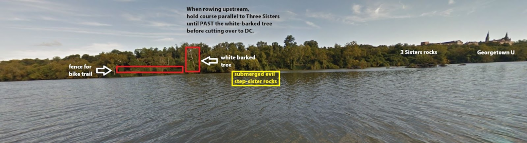
Image and graphic courtesy of Margie Orrick, Rock Creek Rowing
- Directly downriver of Three Sisters Island is an ever-growing mudflat that extends about 100 meters from the last rock. This can bottom out most boats, can get boaters stuck, and can damage boats/equipment. Boaters should use caution in this space.
- Paddlers are encouraged to use the DC side of Three Sisters Islands in order to have their own travel lanes separate from rowers that use the VA side.
- Paddlers that are using the DC side of the river above Three Sisters that wish to join the main traffic pattern at/below Key Bridge should cross from DC to VA sides of the river below Three Sisters Islands. Paddlers should only cross when there is no oncoming boat traffic and there is a clear lane. Paddlers should cross quickly and obviously to show other boaters the intention to join the VA side traffic pattern.
- There are mud flats with rocks that appear at low tide located on the VA shore about 200-300m upstream of Key Bridge.
 |
 |
Key Bridge to Theodore Roosevelt Bridge
Traffic Pattern
- After passing through the 2nd arch from VA of Key Bridge going DS crews should maintain a straight course that takes them towards the corner of Roosevelt Island, across from TBC. Crews should maintain a course that keeps them as close to the Island as possible, with faster crews passing to port.
- If a crew plans to stop after passing through the bridge while heading DS they should move towards and across from the sandy beach area on Roosevelt Island.
- Heading DS crews should round the corner of the island, across from TBC, and immediately line up on the first arch of Roosevelt Bridge. It is critical that crews not round the turn and stop immediately after, but go another 50-100m DS so following crews can clear the area and stopped crews without large and sudden course corrections. This reduces the chances for collisions!
- DS crews headed to TBC should round the corner of the Island. per above, and then cut to the other side of the river in front of the Kennedy Center to enter the docking traffic pattern. Crews cutting directly across the river, as if following the 2k course, to line up for docking is dangerous and should be avoided because of the potential for interference with crews headed upstream.
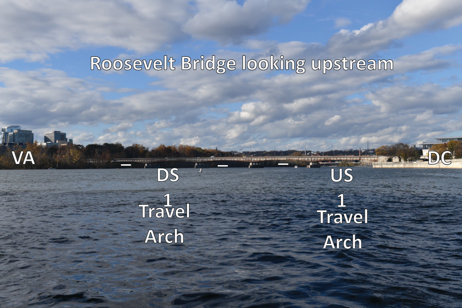
- US crews headed from Memorial Bridge should line up on the 1st arch from DC on Roosevelt Bridge.
- Crews headed to TBC for docking should hug the seawall and those headed farther upstream should stay towards the port side of the arch.
- Coxswains at the point should point to the US end of the TBC docks. As they pass the middle of the Kennedy Center they should line up on the “tower” that sits in the Georgetown Harbor complex.
- Crews should stay wide on the turn headed US so as to stay closer to DC, but remain aware of crews launching from TBC. Cutting the turn too tightly puts crews into the oncoming traffic of the DS travel pattern.
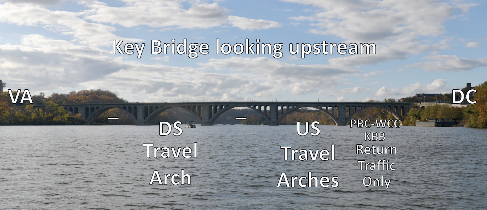
- Once parallel with the DC shore coxswains and sculler should line up with the starboard side of the 2nd arch from DC on Key Bridge.
- The first arch from DC on Key Bridge when headed US is for crew landing at PBC or WCC only!
Hazards
- The area around TBC and the Georgetown waterfront is a designated DC no-wake zone. The no-wake zone runs from Memorial Bridge to Chain Bridge upstream. MPD Harbor Patrol understands that our safety launches following rowers and paddlers are for just that- safety. If launches wake the waterfront and the vessels docked there MPD Harbor Patrol can and will ticket any and all craft leaving a wake. It is best to ensure that when you move through this area you do it with courtesy to all users of the river, and have as minimal an impact on others as possible. If you must slow down or go wide so as not to disturb others, please do so. MPD Harbor Patrol’s deference to us is a courtesy to our community that could be revoked at any time by any officer, which could then cripple coaching activities as we know them. Your behavior in this regard impacts the entire community!
- On low tide/water flow days the corner of Roosevelt Island becomes a mudflat. Crews are advised to make sure to maintain a slightly wider turn around the point so as not to beach on the island.
- There are several submerged rocks and pipes near a rocky outcrop on Roosevelt Island across from Wisconsin Avenue in Georgetown.
- There is a sunken canal barge approximately 250 meters above Theodore Roosevelt Bridge next to Roosevelt Island. The entire T.R. Island shoreline is full of debris. Crews should stay around 50 meters offshore.
- DS of T.R. Island is a mud flat at low tide that also contains several hidden rocks.
- The DC shore between T.R. Bridge and Memorial Bridge (in front of the Lincoln Memorial Stairs) is shallow and often full of snags and debris.
 |
 |
Little River
- The area between the VA shore and T.R. Island known as —Little River“ is shallow and contains snags along either shore.
- Rowing by large boats (8+, 4+, 4x) is discouraged by members of the PRSC because of the limited space and the large impact wakes to have on users in the area.
- The space offers a sheltered space for small boats and paddlers to practice that is outside of the normal traffic patterns where wakes from power boats and wind can have a serious impact on their safety.
- Users entering from the Key Bridge inlet to Little River should stay closer to the VA side of the imaginary centerline of the waterway so as to avoid the rocks near Roosevelt Island.
- Users should travel in the middle third of the river to avoid snags and water plants.
- Heading DS users should exit the main channel by taking the arch closest to the Island. The middle arch may be used as well.
- Once through, crews should proceed towards the VA shore before adjusting the course to parallel the shore. The area between the end of the island towards Memorial Bridge is shallow with rocks.
- Crews should aim for the 2nd arch from VA on Memorial Bridge to reenter the main Potomac Channel headed DS.
- Heading US crews should carefully move towards the VA shore and proceed towards the TR Bridge overpasses.
- As crews arrive at the bridge, they should stay to starboard and take the arch closest to the island. The arch to the port side, which is more in the middle of the channel may also be used, but the approach angle is more severe.
- Once through the bridge, users should move towards the center of the channel and proceed towards the main body of the river. When exiting the channel users should remember:
- The two large rock formations close to the shore of the island, near the mouth of the channel.
- Be aware of crews heading DS through Key Bridge, or upstream on the DC side. Crews in the main river channel have the right-of-way! You must yield.
Memorial Bridge to 14th Street Bridges
Traffic Pattern
- DS Use one arch to the right of the “dark gray” center arch. The gray arch is the navigation channel for power boats.
- After passing through the bridge DS crews should move slowly towards the VA shore and parallel the shore. As crews progress downstream they should aim to go through the arch to the right of the “wooden” navigation channel arch.
- US crews should stay towards DC and try to line up on the 2nd arch from DC. The 1st arch from DC is acceptable but can be tight when many crews approach at the same time. The area after the bridge can be narrowed when the mud flat below the Lincoln steps is exposed.
- Paddlers should follow the general traffic pattern.
Hazards
- This is an open speed/wake zone! That means that power boats of any class can go as fast as they would like and they often do. Their wakes can be large, and the wakes bounce off the rocky shores and bounce back toward the center of the river creating conditions that can endanger crews.
- The biggest hazard in this area is wind. This wide space can go from glass flat to choppy and white caps if the wind comes up quickly. Coaches and individual users should be aware of wind speed, direction, and forecasts.
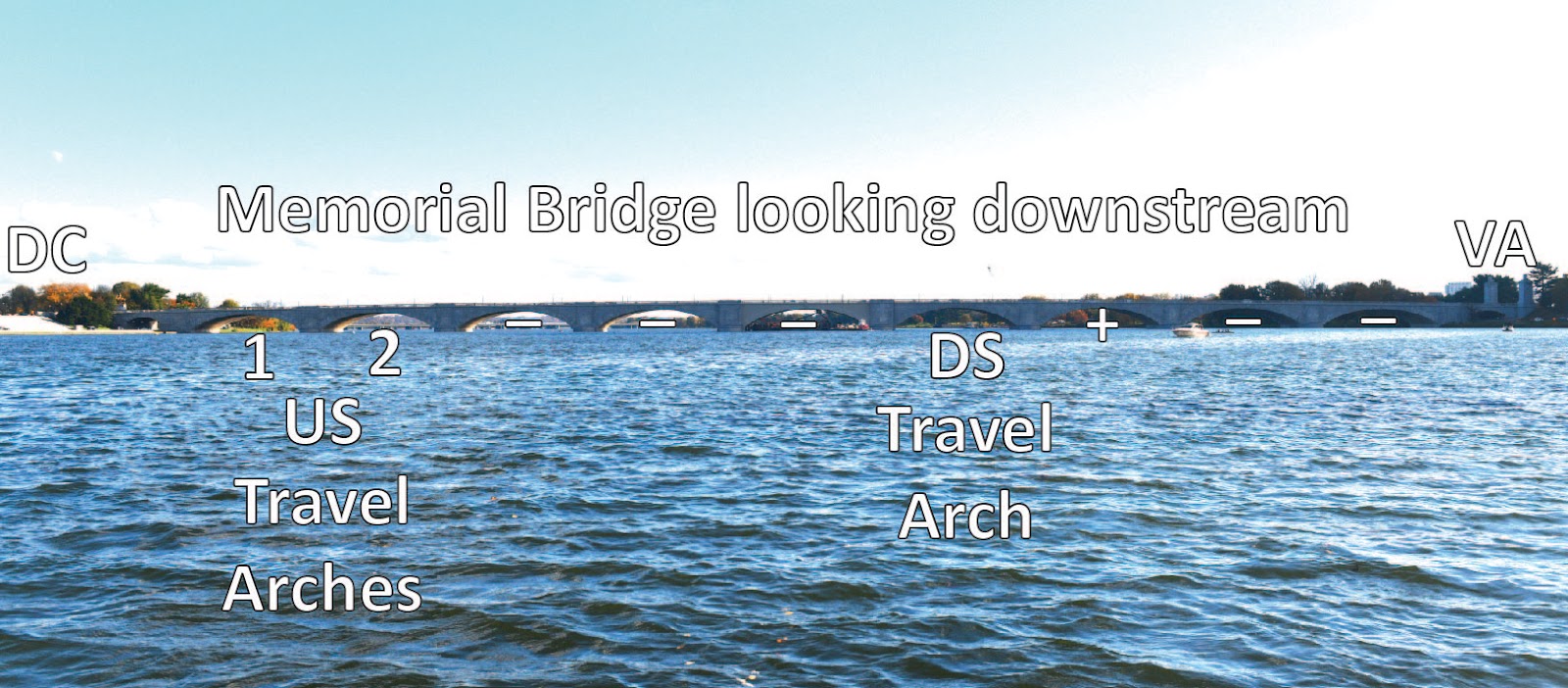 |
| The “+” arch should only be used when exiting or entering Little River from/to the area DS of Memorial. |
 |
14th Street Bridges and Below
Traffic Pattern
- DS crews should use the arch to the right of the Channel Arch (the one with lights and wood buttressing) on both sides. Proceed straight through the remaining bridge piers.
- Once through the bridges users have important choices to make. If heading towards the Anacostia River, crews should aim towards the DC shore and Haines Point to proceed DS and to round the corner where the rivers meet.
- If headed towards the Alexandria waterfront DS, users should stay to the VA shore and follow it around the curve.
- Crews aiming for Haines Point (on the DC shore) should give right-of-way to any crews headed upstream!
- US Crews should follow the seawall on the DC shore of Haines Point and pick a line through the bridges that will give them a clean line through the bridges. About a third of the way from DC shore along the railroad bridge there are two sets of arches that line up and give a straight, unobstructed shot through to the other side.
- Paddlers are encouraged to follow the general traffic pattern.
Hazards
- It is important to remember that this is also an open speed area so power boats can throw large wakes that are dangerous to rowers and paddlers.
- Wind is also a significant consideration, and conditions can change quickly to be dangerous.
- Crews headed towards Haines Point/Anacostia River or towards the Alexandria waterfront area of VA need to be aware that they will be going against the established traffic patterns for rowers in both areas. It is possible that they will encounter crews approaching head on who will have the same level of visibility as they do. Be aware! Further, it is advisable if traveling to these different areas that you consult the traffic pattern information found on the websites for Capital Rowing Club or Alexandria Community Rowing.
River Traffic Pattern Map
